Kodagu is an administrative
district in
Karnataka, India. Before 1956 it was an administratively separate
Coorg State, at which point it was merged into an enlarged
Mysore State. It occupies an area of 4,102 square kilometres (1,584 sq mi) in the
Western Ghats of southwestern Karnataka. In 2001 its population was 548,561, 13.74% of which resided in the district's urban centres, making it the least populous of the 30 districts in Karnataka.
Kodagu is known for its coffee and its people. The dominant group are the indigenous (
Kodavas) and other ethnic groups (Arabashe Gowdas and Kodava subgroups). The chief languages presently spoken in Kodagu are Kodava, Are Bhashe, Kannada, Tulu, Konkani, Urdu and English. Kodagu is home to the native speakers of the
Kodava language.
Geography
Kodagu is located on the eastern slopes of the
Western Ghats. It has a geographical area of 4,102 km
2 (1,584 sq mi). The district is bordered by
Dakshina Kannada district to the northwest,
Hassan district to the north,
Mysore district to the east,
Kasaragod district in west and
Kannur district of
Kerala to the southwest, and
Wayanad district of Kerala to the south. It is a hilly district, the lowest elevation of which is 120 metres (390 ft) above sea-level. The highest peak,
Tadiandamol, rises to 1,750 metres (5,740 ft), with
Pushpagiri, the second highest, at 1,715 metres (5,627 ft). The main river in Kodagu is the
Kaveri (Cauvery), which originates at
Talakaveri, located on the eastern side of the Western Ghats, and with its tributaries, drains the greater part of Kodagu.
In July and August, rainfall is intense, and there are often showers into November. Yearly rainfall may exceed 4,000 millimetres (160 in) in some areas. In dense jungle tracts, rainfall reaches 3,000 to 3,800 millimetres (120 to 150 in) and 1,500 to 2,500 millimetres (59 to 98 in) in the bamboo district to the west. Kodagu has an average temperature of 15 °C (59 °F), ranging from 11 to 28 °C (52 to 82 °F), with the highest temperatures occurring in April and May. The principal town, and district capital, is
Madikeri, or Mercara, with a population of around 30,000. Other significant towns include
Virajpet (Virarajendrapet),
Kushalanagara,
Somwarpet and
Gonikoppal. The district is divided into the three administrative
talukas: Madikeri, Virajpet and Somwarpet. Virajpet is the largest Taluk and comprises the towns Virajpet, Gonikoppal, Siddapura, Ponnampet, Ammathi, Thithimathi etc.
History

Map of South Indian states prior to the States Reorganisation Act, 1956. Kodagu (then called Coorg) is in dark green.
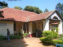
Kalbane Yemmegundi palace
The
Kodavas were the earliest agriculturists in Kodagu, having lived there for centuries. Being a warrior community as well, they carried arms during times of war and had their own chieftains. The
Haleri dynasty, an offshoot of the
Keladi Nayakas, ruled Kodagu between 1600 and 1834. Later the British ruled Kodagu from 1834, after the
Coorg War, until India's independence in 1947. A separate state (called
Coorg State) until then, in 1956 Kodagu was merged with the Mysore State (now
Karnataka).
Coorg in British India
In 1834, the East India Company annexed Kodagu into
British India, after deposing
Chikka Virarajendra of the Kodagu kingdom, as 'Coorg'. The people accepted British rule peacefully. British rule led to the establishment of educational institutions, introduction of scientific coffee cultivation, better administration and improvement of the economy.
Kodagu Culture

Dolls dressed in Kodava attire
The Kodavas are the dominant community of Kodagu. Kodava oral traditions are rich, some of the traditional folk songs have been compiled into the
Pattole Palome . The Kodavas revere ancestors, arms and worship a number of deities, besides the River
Kaveri, some of them being,
Igguthappa, Bhagwathi, Muthappa, Mahadeva, Bhadrakali, Subramani and Ayyappa. Very similar to the Kodavas in religion, culture and language are the Kodava Peggade (Kodagu Heggade), the Amma Kodava, the Airi (artisans), the Meda (craftsmen and drummers) and the Kembatti (labourers).
The Kodava language speakers, other than the Kodavas, include the Kodava Heggade (cultivators of Malabari origin), the Amma Kodava (a mixed race), the Airi (smiths and carpenters), the Thatta (jewellers), some of the Male-Kudiya, the Kodagu Kembatti, the Maringi, the Kapala (of
Siddi origin), the Meda (basket and mat weavers and drummers), the Kanya, the Banna, the Malaya (astrologers of Malayala origin), the Kodagu Golla (cowherds of Mysorean origin), the Kodagu Ganiga (oil-makers), the Kolla, the Kavadi, the Koleya, the Koyava and others.
Traditional costume]
Most of the Kodagu natives, including the Kodavas, the Kodava speakers and the Kodagu Arebhashe Gowdas, wear the traditional Kodava costume. These men wear ‘Kupyas’ (knee-length half-sleeved coats) over a full-sleeved white shirt. ‘Chale’ i.e. a maroon and gold sash is tied at the waist and an ornately carved silver dagger known as ‘Peechekathi’ is tucked into it. ‘Odikathi’ is yet another knife that is tucked into the Chale at the back. Furthermore, a chain with a minuscule gun and a dagger hanging onto it give them a martial look. The saris worn by women are pleated at the back and the pallu fixed with a brooch is also wrapped in a unique way. They wear either a full-sleeved or three-quarter sleeved blouse and cover their head with a scarf. A traditional gold beaded necklace (Jomalae) and a gem-pendant (Kokkethathi) is widely worn by the women of Kodagu.
Kodagu Cuisine
Kadumbuttu and pandi curry is a local dish of Coorg/kodagu, a district in the state of karnataka, India. This dish is made of steamed rice balls and pork curry.
Festivals of Kodagu
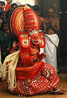
Kodava
Thirrale or daiva theere(called
[clarification needed]Theyyam in Malayalam), similar to another ceremony called the Kola in Kodava, arebhashe,Kannada and Nema in Tulu
Kailpoud/kailmurtha
Kailpoud, celebrated on 3 September, signifies the completion of "
nati", or the transplantation of the rice crop. Officially, the festival begins 18 days after the sun enters the
Simha Raasi (the western sign of
Leo).
Kail means weapon or armoury and
poud means Brighten.
The festival signifies the day when men should prepare to guard their crop from wild boars and other animals, since during the preceding months, during which the family were engaged in the fields, all weapons were normally deposited in the "kanni kombare" (takk in kodava), or the prayer room. Hence on the day of Kailpoud, the weapons are taken out of the Pooja room, cleaned and decorated with flowers. They are then kept in the Nellakki Nadubade, the central hall of the house and the place of community worship. Each member of the family has a bath, after which they worship the weapons before feasting and drinking. The eldest member of the family hands a gun to the senior member of the family, signifying the commencement of the festivities. The whole family assembles in the mand (open ground), where physical contests and sports, including marksmanship, are conducted. In the past the hunting and cooking of wild game was part of the celebration. Now shooting skills are tested by firing at a coconut tied onto the branch of a tall tree.
Traditional rural sports, like grabbing a coconut from the hands of a group of 8–10 people (thenge porata)or("ambu kai"), throwing a stone the size of a cricket ball at a coconut from a distance of 10–15 paces (tenge eed)or("kaai kal"), lifting a stone ball of 30–40 cm lying at one's feet and throwing it backwards over the shoulders, are now conducted in community groups called Kodava Samajas and Kodagu Gowda Samajas in towns and cities.
Puttari/Huthari
Puttari means new rice and is the rice harvest festival (also called huttari in Kannada). This takes place in late November or early December. Celebrations and preparations for this festival start a week in advance.
On the day the whole family assembles in their ain mane (the common family house), which is decorated with flowers and green mango leaves and banana leaves. Specific foods are prepared: tambuttu, puttari kalngi, kesa gende hudka and pache puttu and "rice kheer". Then the eldest member of the family hands a sickle to the head of the family and one of the women leads a procession to the paddy fields with a lit lamp in her hands. The path leading to the field is decorated. A gunshot is fired to mark the beginning of the harvest, with chanting of Poli Poli Deva (prosperity) by all present. Then the symbolic harvesting of the crop begins. The rice is cut and stacked and tied in odd numbers and is carried home to be offered to the gods. The younger generation then light firecrackers and revel, symbolising prosperity. Groups of youngsters visit neighbouring houses and boast their dancing skills and are given monetary gifts. A week later, this money is pooled and the entire village celebrates a communal dinner called 'ooramme'. All family members gather for this meal. Dinner normally consists of meat dishes, such as pork and chicken curry. Alcoholic beverages are also served at such feasts.
Economy
Agriculture
Gambooge or
Kachampulior"Kachulli" (Coorg vinegar)
Kodagu is a rural region with most of the economy based on agriculture,
plantations and
forestry, as well as one of the more prosperous parts of
Karnataka. This is due primarily to coffee production and other plantation crops. Rice and other crops are cultivated in the valleys. Coffee plantations, situated on hillsides too steep for growing rice, and taking advantage of shade from existing forests, became characteristic of the district in the 20th century. Coffee is now a major cash crop. Coffee processing is also becoming a major economic contributor. In recent years tourism has also begun to play a role in the economy. Eco-tourism, such as walking and trekking tours, take advantage of plantation buildings converted into guest-houses
Much of Kodagu is used for agriculture. Characteristically and historically, paddy fields are found on the valley floors, with Coffee and pepper
agroforestry in the surrounding hills mainly near
Madikeri. The most common plantation crop is coffee, especially
Coffea robusta variety. Kodagu is the second coffee production region in India, after the
Baba Budangiri hills in
Chikkamagaluru district. Coffee revenue helped Kodagu to become one of the richest districts in India.
Coffea arabica is also grown in some parts of southern and western Kodagu, the historical area of coffee production. One can go to see the coffee plantation and can understand how sophisticated coffee plantation is and how much perfection and precision it requires it is mandatory to grow coffee in shade so it is grown with the eucalyptus trees and the vanilla. The coffee agro-forestry systems of Kodagu are one of the richest agro-forest in the world, with about 270 species of shaded trees inventoried (see publications of CAFNET project). But the trend is now to replace the native shade trees by exotic ones (such as the
Grevillea robusta). In those coffee agro-forests are also cultivated spices like
black pepper,
cardamon,
vanilla. Besides, the other famous agricultural produce of Kodagu is Kodagu Oranges (
Citrus sinensis) known for its distinctive taste and shrunken nature. Kodagu is also known for its forest
honey. Many other crops are also cultivated, including para rubber,
teak, and
cocoa. There are also large areas of natural forest, especially in the forest reserves in the south and east.
Tourism

Kaveri River in Kushal Nagar

Tibetan Buddhist Golden temple, near Bylakuppe and in Kushalnagar
Kodagu is rated as one of the top hill station destinations in India. Some of the most popular tourist attractions in Kodagu include Talakaveri, Bhagamandala, Nisargadhama,
Abbey Falls,
Dubare,
Nagarahole National Park,
Iruppu Falls, and the Tibetan Buddhist Golden Temple.
- Talakaveri is the place where the River Kaveri originates. The temple on the riverbanks here is dedicated to lord Brahma, and is one of only two temples dedicated to Brahma in India and Southeast Asia. Bhagamandala is situated at the Sangam (confluence) of two rivers, the Kaveri and the Kanika. A third river, the Sujyothi, is said to join from underground, and hence this spot is called the Triveni Sangam. Iruppu Falls is a sacred Kodagu Hindu spot in South Kodagu in the Brahmagiri hill range. The Lakshmana Tirtha River, with the waterfalls, flows nearby and has a Rameshwara temple on its banks. It is said that this sacred river was created when Laxman, prince of Ayodhya and younger brother of Lord Ram, shot an arrow into nearby hill, the Brahmagiri hill.
- Omkareshwara Temple is a beautiful temple built in the Indo-Sarcenic style in Coorg. A legend is associated with the temple, built by Lingrajendra II in 1820 CE. The king put to death a pious Brahmin who dared to protest against his misdeeds. The spirit of the dead man began to plague the king day and night. On the advice of wise men, the king built this temple and installed a shivlinga procured from Kashi, North India.
- Dubare is mainly an elephant-capturing and training camp of the Forest Department at the edge of Dubare forest; on the bank of the river Kaveri along the Kushalanagara – Siddapura road. Nagarahole is a national park and wildlife resort. Nisargadhama is a man-made island and picnic spot near Kushalanagara, formed by the river Kaveri.
- Abbey Falls is a scenic waterfall 5 km from Madikeri. Mallalli falls is 25 km from Somwarpet, downhill of the Pushpagiri hills. Mandalapatti is 28 km from Madikeri. On the way to Abbey Falls, before 3 km from Abbey Falls take right, from there 25 km.
- Abbi waterfall and other waterfalls are best during monsoon season, typically some days after it stats raining in June up to the end of rainy season, while there is more water gushing in the streams and rivers.[11]
Flora and fauna[edit]
The flora of the jungle includes
Michelia champaca,
Mesua (
Ironwood),
Diospyros (
ebony and other species),
Toona ciliata (Indian mahogany),
Chukrasia tabularis,
Calophyllum angustifolium (Poon spar),
Canarium strictum (Black Dammar),
Artocarpus,
Dipterocarpus,
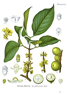
Garcinia,
Euonymus,
Cinnamomum,
Myristica,
Vaccinium,
Myrtaceae,
Melastomataceae,
Rubus (three species) and a
rose. In the undergrowth are found
cardamom,
Areca,
plantains, canes, wild
black pepper,
Cyatheales and other
ferns, and
arums.
Demographics[edit]
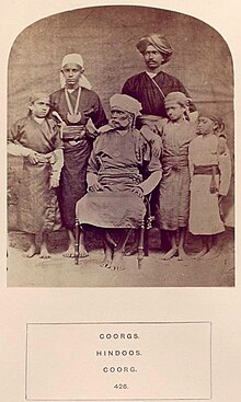
Kodavas, 1875, From "The people of India: A series of photographic illustrations..."(New York Public Library).
Kodava Thak is the spoken language native to Kodagu.
Are Bhashe, a dialect of
Tulu and
Kannada, is native to
Sulya in Dakshina Kannada and now has a significant number of speakers in Kodagu. However, both use the Kannada script for literature.
[14] According to
Karnataka Kodava Sahitya Academy (Karnataka's Kodava Literary Academy), apart from Kodavas, and their related groups, the
Amma Kodavas, the Kodava
Peggade (Kodagu Heggade) and the Kodava
Maaple (
Kodava Muslims), 18 other smaller-numbered ethnic groups speak Kodava Takk in and outside the district including the
Iri (
Airi, or the carpenters and the village smiths), the
Koyava, the
Banna, the Kodagu
Madivala (washermen), the Kodagu
Hajama (barber, also called Nainda), the
Kembatti Poleya (household servants and labourers) and the
Meda (basket and mat weavers and drummers).
[15]
Besides Kodavas and Kodava speakers, other large communities that now reside in Kodagu District are the
Kodagu Gowdas (who speak Are-bhashe dialect and originally from
Sulya) and the
Muslims (
Urdu or
Kodava). The main hunter-gatherer forest dwellers of Kodagu are the
Kudiya, the
Yerava (also called Adia) and the
Kuruba. There are also families of the
Brahmin community, most of whom were brought here for the purpose of offering poojas at various temples.
Kodava people
Kodagu is home to many communities with diverse ethnic origins, with the dominant
Kodavas being the main ethnic group. Despite the native
Kodavas, forming only one-fifth of the total population of Kodagu as most of them have moved to the cities, like Bangalore and Mysore, and even abroad, to regions like North America, they are however still the largest group in Kodagu. The Kodavas owned their farms, growing paddy in the fields, pepper, areca, coconut, cardamom, coffee and other crops in their hill orchards and woods. Guns and swords are essential for their religion, as ritual cult objects, and they hold rights to carry light arms.
The Kodavas Hindus are traditionally
ancestor worshippers with a martial tradition, hence may be called
Kshatriyas. In Kodagu, the Kodavas were owners of land, the caste of Kembatti Poleya, were the farm labourers who worked for them. They are not vegetarians, but they do not eat beef. They are polytheists and believe in a number of deities. The chief deities are Bhagwathi (
Parvati), Mahadeva (
Shiva),
Muthappa,
Bhadrakali (a form of Parvati as
Kali or
Durga), Subramani (
Subramanya) and
Ayyappa.
Igguthappa, the most important local god, is an incarnation of Subramani, the god of snakes, rain, harvest and rice.

The Dravidian Languages: notice Kodava/ Kodagu language (rough estimates)
The ancient folk songs (some of them are compiled in the
Pattole Palome) sing of the numerous Kodavas and the much lesser-numbered other communities. It also speaks of the social relationships of the Kodavas with the other communities who were the natives of Kodagu and spoke the Kodava language. Airi, Male-Kudiya, Meda, Kembatti, Kapala, Maringi, Heggade, Kavadi, Kolla, Thatta, Koleya, Koyava, Banna, Golla, Kanya, Ganiga, and Malaya are other castes native to Kodagu who speak Kodava. Many of these communities had originally migrated into Kodagu from the Malabar Coast region during the rule of the Haleri dynasty (1600-1834).
Other Kodava speakers
Amma Kodavas, a mixed Kodava origin, live in the southern parts of Kodagu and follow some of the
Brahmin customs. Unlike other Kodavas they are vegetarians, they abstain from alcohol, wear the sacred thread and study the
Vedas. They were the progeny of intercaste marriages between Brahmins and Kodavas during former times. They belong to 44 family names and two
gothras. Otherwise they follow the Kodava habits and customs, dress like other Kodavas and speak Kodava Takk. They were also known as the Kaveri
Brahmins by the British.
Among other Kodava speaking communities are: the
Heggades, cultivators from Malabar; the
Kodava Nair,cultivators from Malabar; the
Ayiri, who constitute the artisan caste; the
Medas, who are basket and mat-weavers and act as drummers at feasts; the
Binepatta, originally wandering musicians from Malabar, now farmers; and the
Kavadi, cultivators settled in Yedenalknad (Virajpet). All these groups speak the
Kodava language and conform generally to Kodava customs and dress.
Jungle-dwellers
The
Kudiya lived in the Western Ghats along Dakshina Kannada and Kodagu and some of them were toddy-makers. While most of them spoke the
Kudiya language, some of the Male-Kudiya (a Kudiya sub-caste) speak a variation of the
Kodava language. The
Yerava also live in adjacent Kerala, where they are known as the Adiya, and are primarily
Hindu farm-labourers. They speak their own Yerava dialect. The
Kurbas were forest hunter-gatherers who are now farm-labourers. They speak their own dialect and belong to two subcastes – Jenu, who are honey-gatherers, and Betta, who are hill-dwellers and good elephant captors, trainers and mahouts.
Kodagu Gowdas
The Arebhashe gowdas,
[16] or
Kodagu Gowdas, and Tulu Gowdas, are a major ethnic group of
Dakshina Kannada and Kodagu. They live in Sulya (in Dakshina Kannada) and in parts of Somwarpet,Kushalanagar, Bhagamandala and Madikeri. Guddemane Appaiah Gowda along with many other freedom fighters from different communities revolted against the
British in an armed struggle which covered entire Kodagu and Dakshina Kannada. This was one of the earliest freedom movements against the British
[17] called "
Amara Sulliada Swantantrya Sangraama"
[18] (
Amara Sulya Dhange[17] formally called the 'Coorg Rebellion' by the British) started in 1837.
[19][20][21][22]
Muslims and Christians

The entrance of the Tibetan Buddhist Golden Temple and monastery
Kodagu is home to a sizeable population of Muslims. Those Muslims who are of South Western Indian origins are known as the
maaple, either Malayalam speaking in Kerala and Kodava speaking in Kodagu. Kodava Hindus converted into Islam were called
Kodava maaple, or
Jamma Maaple. Some of the
Kodava maaple (Kodava-speaking) have married with Malabar
Mappila (Malayalam speaking) and Tulu
Bearys. A number of Muslims from the Malabar coast (Kerala
Mappilas), have settled in
Virajpet (the Southern part of Kodagu) as traders. Those who speak Urdu and are of Persian (or sometimes Arab or Afghan) origins call themselves
Sheikhs but are locally known as the
Turks (Turqa). They settled when the Mysore Sultans ruled in Kodagu.
A small number of
Mangalorean Catholics are also found in Kodagu. They are mostly descended from those
Konkani Catholics who fled the roundup and, later, captivity by
Tippu Sultan. These immigrants were welcomed by Raja Virarajendra (himself a former captive of Tippu Sultan, having escaped six years of captivity in 1788) who realising their usefulness and expertise as agriculturists, gave them lands and tax breaks and built a church for them.
Others
There is a sizeable population of the Brahmins and the
Lingayat people and the majority of them are in the taluk of
Somwarpet. A large number of the present people of Kodagu, nearly three-fifths, are mainly agriculturists (
Vokkaliga) and labourers (
Holeya) who arrive from the Mysore region and speak Kannada in Kodagu. Those from
Hassan District are called the
Badaga ('Northern') people. Also a large number of traders are Muslims (Maaple) from Kerala and speak Malayalam. Besides Kodava and Kannada, Arebhashe, Konkani, Malayalam, Urdu and Tulu are also spoken in Kodagu. Kodagu also has a
Tibetan Buddhist refugee population as well, mainly settled around
Kushalnagar.
Notable people
- Field Marshal K. M. Cariappa, first Indian C-in-C, High Commissioner of Australia and New Zealand
- General K. S. Thimayya, head of Indian Army, chairman of Korean Repatriation Committee, head of UN Peacekeeping force
- Lt Gen Apparanda Aiyappa, head of Signals Corps, later head of Bharat Electronics Limited
- Squadron Leader Ajjamada B Devaiah, Maha Vir Chakra (Posthumous), 1965 Indo Pak War, he was known as 'wings of fire', died in Pakistan.[25]
- C B Muthamma, first woman IFS officer
- Rao Bahadur P. K. Monnappa police chief of three states
- C. G. Somiah, Comptroller and Auditor General of India (1990–1996).
- Pandyanda Belliappa, freedom fighter and Gandhian.
Iynanda P Kariappa, freedom fighter and member of the I.N.C, one of the first M.L.A's of Coorg state and District board president.
- Diwan Bahadur Ketoli Chengappa, last Chief Commissioner of Coorg
- Leefe Robinson, World War II pilot, VC recipient
- Frederick Nicholson Betts, ornithologist
- Prema, Kannada actress.
- B D Ganapathy, writer and journalist
- Biddu Appaiah, music composer
- M. P. Ganesh, former hockey team captain, Olympian and coach, 1973 Arjuna Award.
- B. P. Govinda, team hockey player, 1975 Arjuna Award.
- Kodagina Gowramma, Kannada feminist writer
- Zulfi Syed, Super model and actor
- Sommayya Maneypande (M M Somaiya) former Indian Hockey team player, captain, Olympian,Arjuna Awardee 1985, Hockey Gold Medalist 1980
- Arjun Halappa, hockey player
- Ashwini Nachappa, athlete, 1988 Arjuna Award
- C.C. Machaiah, (Chenanda Machiah) former boxer,Olympian and coach, 1978 Arjuna Awardee
- Robin Uthappa, international cricket player
- Rohan Bopanna, tennis player
- Ashwini Ponnappa, badminton player
- Joshna Chinappa, squash player
- Jagat and Anita Nanjappa, former national rally champions
- C M Poonacha, Chief Minister of Coorg State, Member of Parliament from Mangalore, Governor of Orissa and Madhya Pradesh
- Prema Cariappa, former mayor of Bangalore, Rajya Sabha MP
- K.G. Bopaiah (Speaker of Legislative Assembly/ Virajpet MLA)[26]
- M P Appachu Ranjan, Ex-Minister and Member of Karnataka Legislative Assembly
- Charles Davy, cricketer
- V. R. Raghunath, Indian team hockey player.
- S. K. Uthappa, Indian hockey team player.
- Major M C Muthanna, war martyr
- Gundugutti Manjunathayya, Freedom fighter, Member of the legislative assembly (1952-1957), State of Coorg.
- Sadguru Appayya Swami, head of Kaveri Ashram (monastery)
- Swami Narayanananda, head of a monastery in Denmark
- Swami Shambhavananda, a Hindu monk known for his efforts to promote malaria eradication and beekeeping, head of Ramakrishna Mission, Ponnampet monastery.
- Shri. Nidyamale Somana, Member, First Lok Sabha (1952–1957), Parliament of India, represented the State of Coorg; MLA (1957–1958), Karnataka State, represented Piriyapatna Constituency[27]
- Dambekodi S. Madappa (Ex-MLA)[28]
- S. V. Sunil, Indian hockey team player.
- Shwetha Chengappa, Kannada actress
- Nidhi Subbaiah, Kannada actress
- Daisy Bopanna, Kannada actress
- Harshika Poonacha, Kannada actress
- Ramya Barna, Kannada actress
- Nishan K. P. Nanaiah, Hindi and Malayalam actor
- Anjana Appachana, novelist
- Boverianda Nanjamma and Chinnappa, eminent research scholars
- Guddemane Appaiah Gowda, the first freedom fighter of Coorg around 1834-1837.[28]
- Baddana Raj Chengappa - Editor-in-Chief, Printer & Publisher, The Tribune; Chandigarh, India.[29][30]
- P T Bopanna, author and journalist.
- Prof P S Appaiah, eminent scholar
- A. T. Raghu, Film and serial director
- Dinesh Gundu Rao, politician
- N.S.Deviprasad (Sampaje Deviprasad), Film Producer and Cultural activist & Activist for 'Praja Vedike'[31]
- B. B. Ashok Kumar, noted police officer.
- N S Narendra, eminent entrepreneur, managing director of FirePro Systems
- Ajjinikanda C. Mahesh Nachaiah, Editor, Poomaale Kodava News Paper
Transport
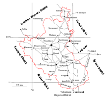
Road map of the district.
Education
Some of the notable college institutions of the region are:
- Coorg Institute of Dental sciences, Virajpet
- Government Engineering College, Kushalnagar.
- College of Forestry, Ponnampet, University of Agricultural Sciences (B).
- Coorg Institute of Technology, Ponnampet.
- Field Marshal K M Cariappa College, Madikeri


